
Sitemap
A list of all the posts and pages found on the site. For you robots out there is an XML version available for digesting as well.
Pages
Posts
FastSpeech 2 and 2s: Fast, High-Quality, and Fully End-to-End TTS
Published:
FastSpeech 2 simplifies the TTS training pipeline by eliminating the teacher-student distillation process and adding pitch, energy, and duration as explicit conditioning features. FastSpeech 2s takes this a step further by directly generating waveform in a fully end-to-end manner.
Transformer TTS
Published:
In this post, I’ll highlight Transformer TTS, which brought the Transformer architecture to neural text-to-speech (Speech Synthesis). The model directly addresses two major limitations of RNN-based systems like Tacotron 2: poor parallelism and weak long-range dependency modeling. Instead of relying on recurrence, it uses self-attention throughout. This allows the model to train much faster without sacrificing output quality, and in some cases, it actually improves it.
portfolio
Conditional Variational Autoencoder for facial attribute manipulation
A conditional variational autoencoder (CVAE) trained on the CelebA dataset to generate facial images conditioned on specific attributes, enabling controlled facial attribute manipulation.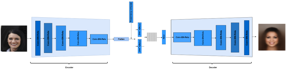
Supervised Facial Image Denoiser
A supervised autoencoder-based image denoiser using the CelebA dataset, achieving effective noise reduction while preserving facial details.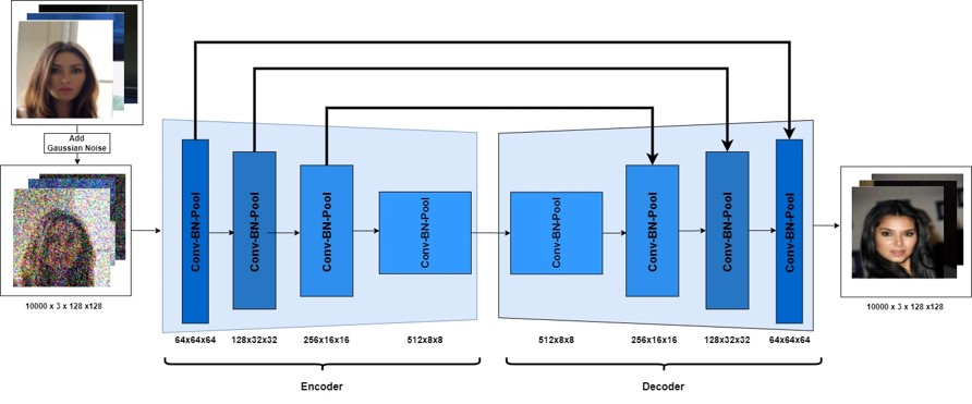
Extended Relaity framework using Unity and Mapbox
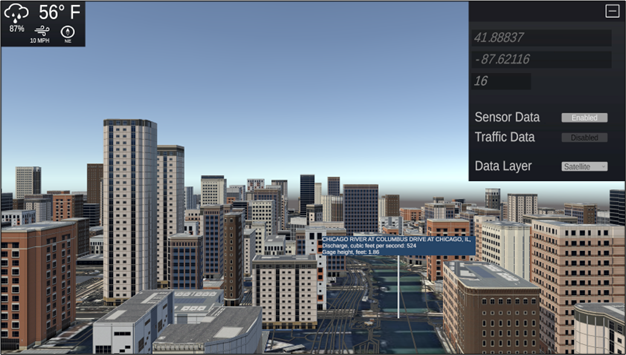
Framework that leverages Extended Reality (XR) to revolutionize hydrologic data visualization and enhance environmental planning, paving the way for future applications in hydroinformatics and digital twin systems using Unity Game Engine, Mapbox SDK for Unity, VRTK and WebXR for delivering immersive experiences directly through web browsers.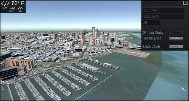
publications
An Immersive Hydroinformatics Framework with Extended Reality for Enhanced Visualization and Simulation of Hydrologic Data
Published in Applied Sciences, 2025
This study introduces a novel framework with the use of extended reality (XR) systems in hydrology, particularly focusing on immersive visualization of hydrologic data for enhanced environmental planning and decision making. The study details the shift from traditional 2D data visualization methods in hydrology to more advanced XR technologies, including virtual and augmented reality. Unlike static 2D maps or charts that require cross-referencing disparate data sources, this system consolidates real-time, multivariate datasets, such as streamflow, precipitation, and terrain, into a single interactive, spatially contextualized 3D environment. Immersive information systems facilitate dynamic interaction with real-time hydrological and meteorological datasets for various stakeholders and use cases, and pave the way for metaverse and digital twin systems. This system, accessible via web browsers and XR devices, allows users to navigate a 3D representation of the continental United States. The paper addresses the current limitations in hydrological visualization, methodology, and system architecture while discussing the challenges, limitations, and future directions to extend its applicability to a wider range of environmental management and disaster response scenarios. Future application potential includes climate resilience planning, immersive disaster preparedness training, and public education, where stakeholders can explore scenario-based outcomes within a virtual space to support real-time or anticipatory decision making.